|
Tithe Maps, St Albans, 1838-47 January, 2010 |
|


David Thorpe (thorpeds @t hotmail.com) of Little Hampden asks: Please do you know whether the Tithe maps for the parishes of St Albans show the town centre and document the individual buildings. Also is there a 100 inch to mile map for the town circa 1875.
The area, and many of the property boundaries, of the historic Borough of St Albans date back to Saxon times, and significant developments outside the area only really started in the middle of the 19th century. The Borough included the whole of the Abbey parish and parts of the parishes of St Michael, St Peter and St Stephen. (These three churches were originally chapels to welcome pilgrims coming to the Abbey of St Alban.)
There are tithe maps for all four parishes:
- St Albans is dated 1847 and is at a scale of 40 inches to the mile. (HALS DSA4/85)
- St Michaels is dated 1840 and is at a scale of 26.7 inches to the mile. It includes the urban part of the parish. (HALS DSA4/87)
- St Peters is dated 1840 and is at a scale of 13.3 inches to the mile with the common fields at 26.7 inches to the mile, It includes the urban part of the parish. (HALS DSA4/88)
- St Stephen is dated 1838 and is at a scale of 26.7 inches to the mile. It includes the urban part of the parish. (HALS DSA4/89)
 In
addition to holding copies of the maps I believe
HALS also holds the
apportionment books, which should contain the names of the owners and
occupiers of all properties in both the urban and rural areas. However I
have not examined these myself and I suspect that they would not
identify the sub-tenants who had accommodation in the various Inn yards.
In
addition to holding copies of the maps I believe
HALS also holds the
apportionment books, which should contain the names of the owners and
occupiers of all properties in both the urban and rural areas. However I
have not examined these myself and I suspect that they would not
identify the sub-tenants who had accommodation in the various Inn yards.
The earliest large scale Ordnance Survey of the area was published in 1878 at 25 inches to the mile, and this survey was republished shortly afterwards at 6 inches to the mile.
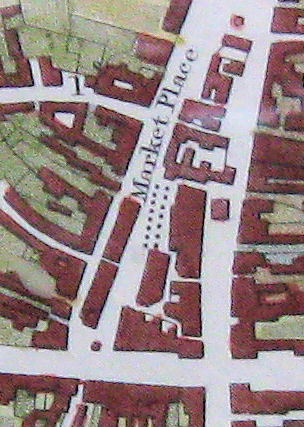
You don't say what you want the maps for - but there are other large scale maps and plans, both manuscript and printed, which cover the town, individual properties (estate maps, title deeds and sales particulars) and developments (such as the turnpike roads and later the railways). The detail on the right comes from the 1822 printed map produced to go with Clutterbuck's The History of the County of Hertford. In addition, some years ago the St Albans and Hertfordshire Architectural and Archaeological Society produced a large scale reconstructed survey of the ancient borough as it was in 1820.
You will find HALS the best place to start looking, but there may be material in the St Albans Central Library. However such material can turn up in unexpected places. I have done quite a lot of research on the adjacent rural parish of Sandridge and a large 18th century estate map has been bound into a book of estate maps held in the British Library, while relevant linked documents are held in the Northamptonshire Records Office.
| January 2010 | Page created |
| February 2010 | Date of Arch & Arch Soc map corrected. |