|
Uncle's Farm, Little Hadham, 19th Century March, 2014 |
|
||||||

Jean Bacon (jbpeanuts @t googlemail.com) of Guiting Power, Glos., writes: I'm hoping you can help me locate 'Uncles Farm' near Little Hadham, Herts. According to the 1891 census, my great-grandfather, Arthur Trigg farmed there. I've found Green Street, where he lived at the time of the 1881 census and Church End, where he was for the 1851 and 1871 censuses but despite trying various chapters of your website and the Ordnance Survey site, I can't locate Uncles Farm. I found a query about a Joseph Uncle, thought to come from the Little Hadham area, when I googled Uncles Farm, so I think the name on the census is genuine.
I have checked a number of maps [listed] and my question to you is whether you can suggest any other sources that might solve my problem? I plan to be in the area at the beginning of May and would like to visit the [site of the?] farm if I can, so any advice you can give would be extremely useful.
Uncle's Farm, Little Hadham. 1891
| TRIGG, Arthur | Head | Married | M | 64 | 1827 | Farmer | Little Hadham, Hertfordshire |
| TRIGG, Elizabeth | Wife | Married | F | 55 | 1836 | Rougham, Norfolk | |
| TRIGG, Octavious | Son | M | 23 | 1868 | Farmers Son | Little Hadham, Hertfordshire | |
| TRIGG, Arthur | Son | M | 13 | 1878 | Farmers Son | Little Hadham, Hertfordshire | |
| TRIGG, Jonathan | Son | M | 11 | 1880 | Scholar | Little Hadham, Hertfordshire |
|
General advice on location at least approximately where your ancestor lived is given on my page Locating Census Addresses on Maps. For all the censuses between 1841 and 1901 the start of each enumerators book includes a summary of the area covered by the book and the properties are then visited in order. If you look at the actual page containing Arthur Trigg's entry in 1891 and scan several pages in either direction you can work out the route the enumerator took to get to Arthur Trigg's farm. First there were a lot of houses, including a pub, at Bury Green, Little Hadham. You then come to the following properties
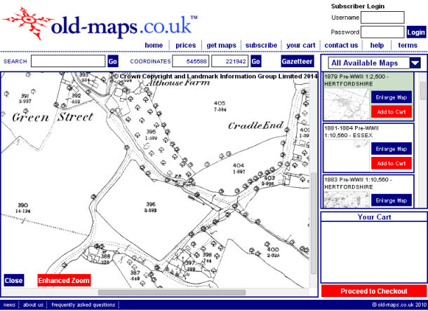
And there are a whole lot of properties at Cradle End. This tells us that the enumerator walked round Bury Green, then passed Vineyard House (possibly used as farm labourer accommodation with two families there), then Uncle's farm, and then he came to Green Street (including two farms occupied by farm labourers) and then he moved on to Cradle End. You now need to look at some online maps and the best site for you is www.old-maps.co.uk. This provided a high resolution modern Ordnance Survey Map and a whole selection of earlier maps. I located Green Street, Little Hadham, and it gave me a list of properties , and I selected the distinctively named Att House Farm, which occurred on the census returns. This took me to a modern map of the area. I then selected the 1879 large scale map of the area, and got the following:
The road in the bottom left corner comes from Bury End, Little Hadham, so the first property you come to is number 388, which appears to be one small building divided into two - could this be Vineyard House? And could building on plot 397 be a farm? perhaps even Uncle's Farm? Returning to the modern maps you find this is now described as Ivy Farm. Don't get me wrong - I am not saying that these are the right properties but simply saying they look as if they may be. I have assumed that Vineyard House and Arthur's Farm are the first buildings you come to when you enter Green Street - but of course you will also have to look to see what the last buildings are as you leave Bury End. However the 1881 census suggests he was at the Green Street end of the road. You should check the 1871 and 1881 censuses to see if, when compared with the map, they tell the same story. Making notes of the names and occupations could help relating properties between the censuses if there are any ambiguities. I can't comment directly on the name "Uncle's Farm" but the census returns shows that there were a number of people called Uncle in the Bishops Stortford area, and there may be records at HALS, including the tithe map, such as land tax, perhaps account books, estate papers, etc, and when you visit Hertfordshire you may want to start by including a day in Hertford to see what the archives hold. |