WILLOUGHBY, The Springs, Turnford, Cheshunt, 19th/20th Century
August, 2003
|
|
||
|
|
|
|


This page has been archived - no further updates - see Mothballed Pages
|
WILLOUGHBY, The Springs, Turnford, Cheshunt, 19th/20th Century August, 2003 |
|
||||||
|
This page has been archived - no further updates - see Mothballed Pages |
|||||||
Barbara Wyley (jbwyley
@t xtra.co.nz) of
Kaitaia, New Zealand writes: I am trying to pinpoint the exact location
and nature of "The Springs" at Turnford. I first found mention of the
name in the NZ newspaper notice reporting the death of my
great-great-grandfather, Alfred Talbot WILLOUGHBY, at
Turnford in 1886.
His residence is also given in the 1881 census index as "Turnford, The
Springs", and in the probate of his will he is described as "late of
The Springs, at Cheshunt".
The 1873 Return of Owners of Land for the County of Hertford shows Alfred T
WILLOUGHBY of Turnford as owner of 8 acres, 3 roods and 14 perches of land, with
a gross estimated rental of £130. Unfortunately the location of holdings
is not specified, but this may refer to The Springs. In his will he refers
to "my private dwelling house at Cheshunt and the land and premises
belonging thereto".
According to baptismal records the WILLOUGHBY family appears to have arrived in
Turnford in the late 1840s. In the subsequent censuses, the family were
enumerated thus: 1851: "Turnford Cottage"; 1861 &
1871:"Turnford". I do not know if all these descriptions apply
to the same property; the enumerators' routes seem to have been different from
census to census. However, on the "old-maps" website I was able to
view a close-up of the area which showed a Turnford Cottage just south west of
Slipe Lane, which location seems to correspond with the position of the
road called The Springs in modern street maps of the area.
I understand "The Springs" was sold after the death of
Alfred's widow
in 1892. I am told that there is a modern housing estate in the area now,
and a college of education. I am wondering if either if these possibly
occupies the land which was known as The Springs, and if so, is there likely to
have been any mention or description of the house in local newspapers, when, or
if, it was destroyed to make way for these developments?
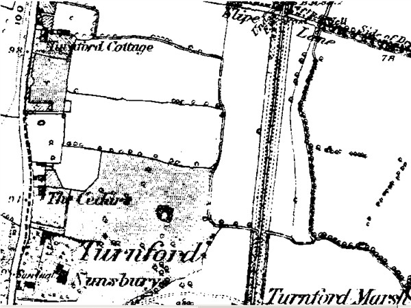
To provide a framework for discussion I reproduce the following section from the old-maps web site showing the area as it was in about 1880. From West to East shows
Land would have to have been acquired to build the railway line and there may well be surviving maps and other documentation relating to the land that had to be acquired, and the ownership. However this was probably before Alfred Willoughby came to Turnford. (He is not listed under Cheshunt in a 1846 Post Office Directory - but I am not sure that this directory covered Turnford).
In fact he may well have moved there because the railway had been built, The railway made journeying into London much easier, as commuting started very early. (My great grandfather, Jacob Reynolds, is believed to have commuted from Hatfield to the City of London in the 1850s.) The areas mentioned in 1873 land returns would suggest that Alfred Willoughby could have owned Turnford Cottage and also some of the adjoining fields between the High Road and the Railway Line, and perhaps up to Slipe Lane.
The first reference to "The Springs" by name I was able to spot in the directories available to me was a Miss Willoughby who was at The Springs, Turnford in the 1890 Kelly's Directory. It may well be that the name was taken on after rebuilding or significantly changing Turnford Cottage. I spotted two later references to a Mrs Deacon living there in 1912 and 1922.
Working backwards from the present day the Hertford Regional College website (http://www.hertreg.ac.uk) has a map which shows that it is entered from a road called "The Springs" but place the college further south than the above map, with what is probably a housing estate where Turnford Cottage used to be. The College used to be the East Herts College of Further Education, High Road, Turnford, A search for this on the web revealed that it was founded in 1961 and occupied the grounds of two large houses, Nunsbury and The Cedars, both now demolished (and both shown on the above map). This information came from an interesting looking site http://www.lowewood.com/turnford.htm which has a lot of history on the area. You may well find that this site allows you to contact people who live in the area and can tell you more about what happened to the house, etc.
July, 2004
Barbara Wyley has alerted me that http://www.lowewood.com/turnford.htm is currently "closed" for changes.