|
The Wheatsheaf, Wadesmill, 1800-1860 December, 2012 |
|
||||||

Jan Robins (jan_robins @t hotmail.com) write from Enfield: My daughter has recently purchased a cottage on Wadesmill Hill(39 Cambridge Road). We have several conveyance references spanning the years 1844 to 1860, and at some time during this period it was a beer house called The Wheatsheaf and was owned by various brewers. More recently it has just been called Wheatsheaf Cottage. The problem is, we cannot establish when it was built as there are no references to it on the copies of documents we have looked at at County Hall prior to 1823. It is believed that the cottage next door (No.38) dates from the late 1700's. As it is the last house in the village going towards High Cross,next to the chalk pit used when it was turnpike road, the maps we have looked at do not extend that far ouside of Wadesmill/Thundridge village. The cottage is sited right opposite the Thomas Clarkson memorial.
She later adds: I do have several names to reference from the various conveyancing notes, but they are all for the period I previously mentioned, and I am looking for something earlier. This earliest ref. I have is an indenture of lease between Laban Sweeting and his wife Mary Cock, and William Payne and his wife Elizabeth in the 1st part - and William Cobham, James Green and James Wortham in 1823. This all sounds like landowners rather than tenants, and that while it was a beer house, maybe nobody actually lived there, and that has been my problem because the cottage does not appear to have been lived in and loved!!!From that date the cottage has changed hands and usage many times until 1864 (DE/A/1416 in 1844 to DE/A/1424 in 1864) from when it does not appear to be referenced anywhere and was not actually registered with Land Registry until my daughter puchased it. There is however a reference in 1844 on conveyancing note DE/A/1416 which reads 'formerly in occupation of - Bunce' .
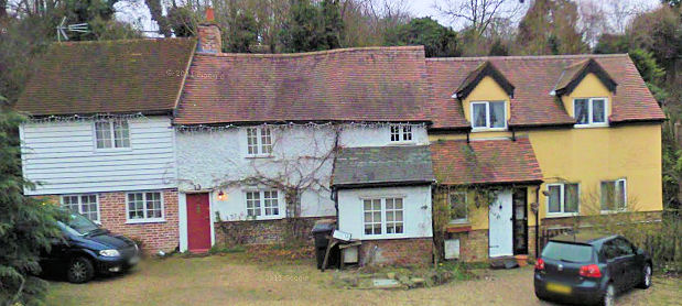
Google Streetview of Wheatsheaf Cottage,
HALS hold quite a number of estate and other maps relating to Standon and Thundridge, some from the 18th century, and a map which could be a draft tithe map. (I don't know if the tithe map for Thundridge exists). Of course some of these maps only include the holdings of a particular owner and may not include the buildings of interest - but I will assume that you have seen all relevant holdings.
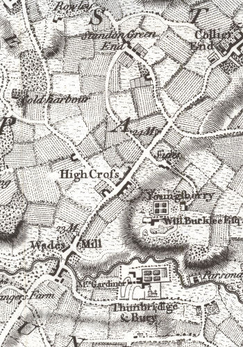
The map here is a detail from the 1766 map of Hertfordshire by Dury & Andrews and Wheatsheaf Cottage is on the south east side of the road to Cambridge by the 23 mile (from London) milestone. Unfortunately the map is not quite detailed enough to be certain of indentifying any cottages. The important thing to realise is that the houses at the northern end of Wades Mill were in the parish of Standon and not the parish of Thundridge. This means that any searches should really cover documents relating to both parishes. I am afraid I am not sure which manor the house was .
The problem you face is a very common one with small scale domestic buildings. While earlier documents may exist that relate to a particular building it may be difficult to identify which building or buildings the document refers to. For example you might find a will might refer to "my cottages at Wadesmill" which is only meaningful if you already know owned what! The task is like trying to determine the subject of a jigsaw puzzle when you only have a few of the pieces, and unfortunately in many cases the critical pieces are missing.
To get a clear idea of what you are looking for you need to understand the architectural history of the building as older buildings such as the above will have been changed over the centuries. Ideally this is done before any redecorating or alterations hide vital evidence. Such surveys can lead to surprises For instance a "Victorian" shop in Berkhamsted was known to have a 17th century room upstairs and was not deemed to be of particular historic interest. A few years ago a builder was called in to make some changes he found a 13th century crown post holding up the roof. What had happened was that the building had been rebuilt over the years by remodelling the lower levels while keeping the roof in place. It is extremely unlikely that the former Wheatsheaf public house is anything like as old - but but the roof timbers the roof timbers of the middle section could well tell an interesting story and there may be evidence that it once had a thatched roof.
It is also important to remember that the building fronts onto a road build by the Romans nearly two thousand years ago and while it is clearly not that old archaeology might reveal Roman remains under the property! After the Romans left the parishes such as Thundridge grew up near the River Rib and the old Roman road was little used. Many years later traffic started to increase and the Wadesmill, High Cross, Colliers End and Puckeridge can be considered as ribbon development - providing services for the people travelling along the revitalised Roman road. (See Village development along the Old North Road.) In 1663 an act was passed because "by reason of the great trade of barley and malt that came to Ware, and is to be conveyed by water to the City of London," the road is "very ruinous, and became almost impassable, insomuch that it became very dangerous to all his Majesty's liege people that pass that way." As a result the first toll gates were established to provide money for improving the road, the one in Hertfordshire being at Wades Mill. The result of the road improvements would have been increased traffic - and the need for increased "motorway service station" type facilities for people such as Thomas Clarkson, their horses, and their carts and carriages.
See Traffic passing through Wadesmill in the 19th century
As the Wheatsheaf was the first building as you entered Wadesmill on your way towards London it was a good position to catch the tired walker or rider needing refreshment. However the building could well have been the home of a blacksmith or a wheelwright, or even stables later converted to living accommodation. The architectural survey (and perhaps a metal detector search of the garden) might give clues as to previous uses.
At the same time it is important to find out who lived there and who owned it - and the documents you saw at HALS should have provided some names. Normally it possible to identify the building and its occupants from the census returns between 1841 and 1911 and this would give the name of the occupant in 1841 and you could then look for the name in earlier records - such as the land tax returns at HALS. However I had a quick look and the returns for 1841 (in the Standon and not the Thunbridge enumerator's books) describe all properties simply as "Wadesmill" and there is no obviously relevant property. The 1851 census is worse as the enumerator failed to record the returns correctly and not only is there no obvious "Wheatsheaf" but entries appear to be in random order. However the 1861 census had the following entry (click to enlarge).
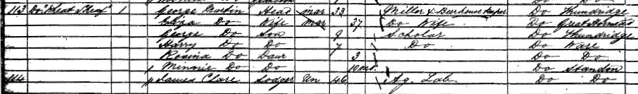
It shows that George Martin was a "miller and beerhouse keeper" at the Wheat Sheaf and this entry may explain why the Wheatsheaf is not listed in the 1851, 1866 and 1882 trade directories for Hertfordshire. It was not uncommon for the head of household to have a regular job, with beer consumed in the front room of the house being a secondary income. Unlike inns - which provided more facilities - beer houses are less likely to be recorded by name in surviving records.
I can't advise on specific documents because I am not aware of exactly what documents survive for Thundridge and Standon, or how helpful they are. For other parishes I have found useful information from Land Tax returns (which survive between 1712 and 1831) and it could help if the Standon returns clearly identify which properties were in Wadesmill because the number of such properties is small. If you were very lucky a baptismal register might register that the parents were from the Wheatsheaf. In one search I accidently found key evidence in an overseers of the poor account book when looking for something completely different. The point to remember is that the old documents were not written to help us do research, and things that "everyone knows" were not recorded.
===============
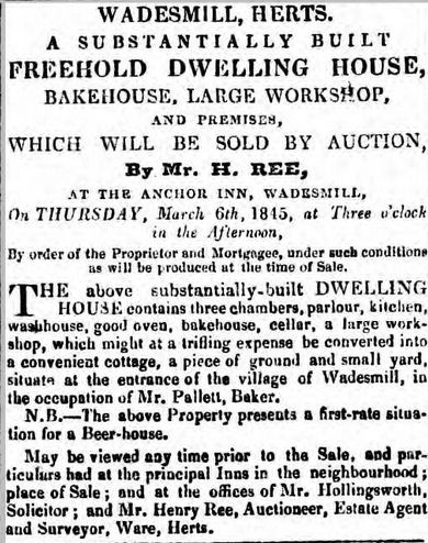 After
drafting this the British Newspaper Archive became available and I
discovered the advertisement on the right, which might refer to the
property in the Hertford Mercury of 1st March, 1845.
After
drafting this the British Newspaper Archive became available and I
discovered the advertisement on the right, which might refer to the
property in the Hertford Mercury of 1st March, 1845.
The 1841 census shows a George Pallett and family living in the Standon end of Wadesmill - but he is described as a surveyor, and not a baker. It may be the wrong person - or his wife might have run been the baker - or the auctioneer might have assumed that as the house has a bakehouse Mr Pallett was the baker!
I also found an advertisement from 1853 for the sale of the Cannon Brewery, Ware, which includes a number of public houses and beer houses, including a definite reference to the Wheatsheaf at Wadesmill.
There may well be other references relevant to the house in the British Newspaper archive - including a number to accidents on Wadesmill Hill, which could have happened on the busy road running past the house.