|
The Road Through Harpenden |
|
The Road Through Harpenden |
Saxon Parish Boundaries
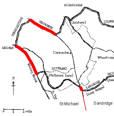
Property boundaries can be very stable over the centuries and the first documentary evidence for the road between St Albans and Luton running through Harpenden is in a deed of 1060 describing the boundaries of Wheathampstead (which then included Harpenden). A modern interpretation, bearing in mind much other evidence, shows the boundary following the line of the Roman road of Watling Street in the west. It also follows "Herpedene," the road from Harpenden to Luton (possibly also Roman) in the north, and continues "from the valley of the highway to the ash at the ford," clearly indicating the presence of a road.
To the south the 1060 deed is less clear, but an examination of the ancient boundaries of the adjacent parishes of St Michael and Sandridge suggests that the road to the south of Harpenden was also a major property boundary since Saxon times.
Original of above map and information on the 1060 deed in Wheathampstead and Harpenden volume 1
<<< Back <<< Index >>> Next >>>
If you can add to the information given above please tell me.