Mill Lane, Tring , 1861
July, 2006
It is often possible to find out where somewhere is by starting at the front of the enumeration book - where there is a description of the route taken by the enumerator and working along the route step by step as described in Locating Census Addresses on Maps. In the case of the 1861 census for Tring the route at the front of the book is actually augmented by a sketch map (although some online census sites omit to include these useful pages).
However helpful it is, there is no mention of "Mill Lane" and several other place names differ from the present day.
Throughout the 19th century there were three mills in Tring. One was initially a watermill near the town centre - at what was sometimes known as Brook End. The old mill house and the mill pond still survive. However early in the 19th century a massive silk mill was built there. This was a factory powered by steam and at one time employing many poor girls from workhouses in London area. The building is now used as a series of offices and workshops.
In addition there were two windmills. The one on Miswell Lane is only a few hundred yards from where I live. The mill house is still there - and the brick tower of the mill is now part of a comparatively new house. This is covered by a different enumeration book so is irrelevant to the query.
The other, named New Mill on the Dury & Andrews map of 1766, has been demolished - but the site is now that of a large (by Tring standards) modern flour mill. The area is now know as New Mill.
Looking back at the 1861 census "Mill Lane" lies between "Brook End" and "New Mill", the current roads being Brook Street becoming Wingrave Road. It could therefore be that the census enumerator was using "Mill Lane" to describe the part of the road that ran between the silk mill and New Mill.
Currently there is a terrace of Victorian cottages alongside the Silk Mill, and two more terraces in Wingrave Road (see New Mill Terrace in EMERY, Tring, 19th/20th Century). There is a long gap in between with a modern block of flats where the gas works had been. I am not sure whether these terraces had been built in 1861.
February, 2008
Mary Pearce (maryrose.pearce @t btinternet.com) of Northants wrote: I used to get from Tring down to New Mill years ago(1955ish) along a lane from the side of John Bly's past the church, going along a track higher than the main road, along to New Mill. Could this have been Mill Lane? Just a thought.
Mary is right about the footpath, which is still there. It now
runs along the boundary between the Silk Mill housing estate on the top of the
hill, and the stream/old mill leet in the valley bottom.
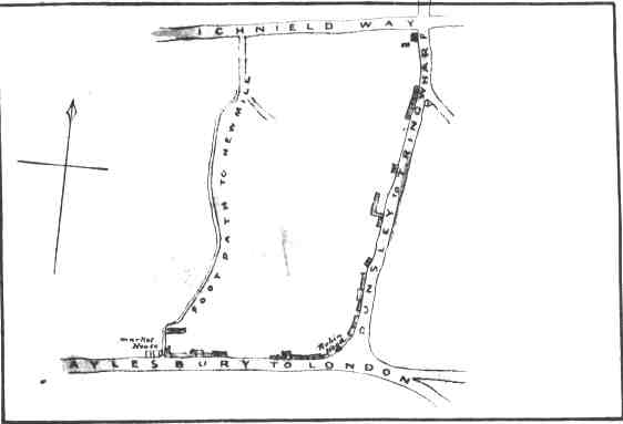
I feel it might be useful to reproduce the map which (very unusually) forms part of the "description of the Enumeration District".
This map clearly shows the footpath Mary refers to but all the names are different to those recorded by the census taker!
The records start with "Parsonage Lane" (the south end of the footpath by the "Market House", now called Church Yard between the High Street and the gateway to the Vicarage.) and then continues east along the "High Street" ("Aylesbury to London"). At the "Robin Hood" public house it turns into "Brook End" ("Dunsley to Tring Wharf" - now Brook Street becoming Wingrave Road when it reaches New Mill). A number of "households" in "Brook End" would appear to be dormitory type accommodation associated with the Silk Mill (the funny shaped building on "Dunsley to Tring Wharf"). There are then 7 households in "Mill Lane" before reaching New Mill where there were about 25 houses and the "Queen's Arms" (at the cross roads with Icknield Way and demolished some years ago to improve traffic flow).
There is a web page for Tring
If you can add to the information given above tell me.