One of the problems I came across in researching the Bernards Heath Brick
works is that there are very few direct references to the clay pits and brick
kilns and their location. In many cases these would be temporary in that
someone wanted some bricks for a major building project they would dig a hole
in a suitable area nearby, and build the temporary clamp kilns nearby. For
instance old Gorhambury House was built of
bricks which were almost certainly made on the estate but the surviving
accounts do not identify exactly where. In some cases where the subsoil was
suitable the bricks are said to have been made from the material excavated to
form the cellars. The earliest map of Bernards Heath,
dated 1726, shows a brick kiln - and also shows a large "bumpy" area
- which are undoubtedly the evidence of many small clay pits which were dug
and abandoned over the preceding centuries. When the Midland Railway opened
there was much building between the town centre and the station, and
brickworks were set up in the area. The same happened in the 1880's and 1890's
with brickworks immediately adjacent to new housing developments in the Bernards Heath area. If the pits were near
housing they would have become rubbish tips and eventually vanished from
sight.
Of course one can find references to brick makers, and
to builders and bricklayers who may have also made bricks - but if any address
is given it is likely to be where they lived rather than where the brick pits
were. This means that most of my locatable references come from law
reports in the press (mostly after 1860), the Sandridge
manor records (of no relevance to the Brickie),
and the published calendar of law
cases. Records of bricks being used in public buildings frustratingly
rarely say where the bricks came from.
This is all a rather longwinded way of saying that I have
virtually no information which can unambiguously be linked to the Brickie. However the following references may
help:
1582: Thomas Hall, M.D., and Margaret his wife
gave the claypits, 9 acres of land in the manor of Kingsbury in St
Albans, for certain doles and to pay the usher Ł2 a year. [from
records of St Albans School]
Frank Kilvington, Letter dated
17rh February, 1997
If you find any names of brick makers that can be linked to
the Brickie let me know and I may have
further details about them on my files.
[P.S. I have another interest, in I have a vague
memory of playing on the Brickie when, as a
young child, I spent a holiday with my grandparents Walter
and Bertha Locke, of Abbey
View Road.]
See also
St
Albans Brickmakers
~~~~~~~~~~~~~~~~~~~~~
Jane Waudby (jane.waudby
@t ntlworld.com)
replied: Thanks for your reply, I have been somewhat wrapped up in the
Street Party we held last Saturday to thank you properly. Thanks for the
possible leads we will follow these up in due course. We had a lot of interest
shown in our Local History Group at the party, so hopefully it will go from
strength to strength.
Can you remember what number your Grandparents lived at
as one of our possible projects is to trace the history of the houses in the
three streets. If you have any photos we would love to see them and possibly
copy them.
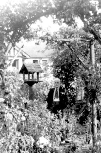
W.R. Locke in garden of 2 Abbey View Road,
in 1937
My grandfather,
Walter Richard
Locke, retired from his job in Hemel
Hempstead in 1926 and moved to Copfield, 2
Abbey View Road, St Albans, shortly afterwards. He worked at Harrow until he retired in 1935, and by 1938 had
moved to Westcliffe on Sea, where he lived
throughout the war - apart from a period working as surveyor at Watchet, Somerset, where my parents and I were
living. After the war he returned to 2 Abbey View
Road, and remained there until about 1950, when my grandmother
became ill and they moved to Devon,
initially with their daughter, Muriel,
wife of Norman Clarke, at that time Bishop
of Plymouth.
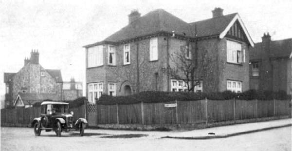
2 Abbey View Road, St Albans, in about
1930?
December 2009
Edward Williams (edward.williams
@t barcap.com) of
New England Street, St Albans writes: I've lived on
New England Street for a couple of
years. Can you find any photos/info of the street pre 1950's? The
street has a park opposite that is called the old
Bricky. More info on this might
lead to info on the street.
As described above there are problems in identifying brick
works and their owners but some information has become available since the
original enquiry, although it doesn't really take us much further as to
providing a precise date or brickmaker's name for the brickworks. However I
suggest some places where answers might be found.
The City of St Albans
(1902) includes the following description of the area:
A Roman Brickfield and Kingsbury Castle.
By passing down Dagnall Street we
reach an open piece of land upon the right, having a bank upon the
opposite side upon which houses and are now built. The great excavations
seen here is supposed to have been caused by the Romans who used the
soil for making bricks; the Saxon times it formed the eastern defence of
the Castle of Kingsbury, erected by
the Kings of Mercia, :and covering a large portion of the elevated land.
The last vestiges of this Castle disappeared in the reign of King
Stephen. By turning to the right along New
England Street we reach
Verulam Road
and see the Hospital; to the left of which lies another and
much larger excavation, also a Roman brickfield, but now a public
pleasure ground.
Unfortunately modern research suggests that
Kingsbury Castle may have been a
Victorian "invention" and is unsupported by archaeological evidence. As a
result there must be some doubt on the assumption that the Romans made
bricks here. Perhaps more significantly it does not mention that it was the
site of brickworks within recent memory.
Some information is available from pictures and maps.
St Albans Museums have
a picture of "The
Brickie Park" from the 1960's (and two later ones which show part of
it) on their web site, and another post World War II picture of
some houses in New England Street.
They have an
engraving (circa 1880) of the Abbey
which shows cattle in the Brickie Park
in the foreground, and a
watercolour from 1867 from a similar viewpoint which suggests that
the area where the cows were circa 1880 was much less even in 1867. The area
is shown simply as open ground in the
large scale OS map survey of
1877 but is marked as a recreation ground in 1897 revision.
The pictures and maps suggest that it was probably no
longer a brickworks in 1867, was very unlikely to be a brickworks in 1880
and was definitely not a brickworks by 1897, The problem is to date it
before this date. There was a lot of brick earth in the
St Albans area, so bricks would often be
made near to where they were used so, for example, the Brickie may have been
active when nearby Portland and
Mill streets were being built in the
mid-19th century - see Pound Field, St
Michaels, St Albans, 19th Century.
However the location is sufficiently near the town centre that brick may
have been made there since the 16th century or earlier.
One possible source of information could relate to
The Brickie becoming a recreation
ground. It could be part of the bequest of "Clay
Pittes" by
Thomas Hall and his wife Margaret in 1582.
Historical Records of St Albans
(1888) mentions a new scheme for managing St Albans
School drawn up in 1879:
One of the most important features in the new scheme is the transference to the
Grammar School of the proceeds of the charity lands of
Thomas and Margaret Hall. Originally only Ł2 per annum was derived from this source, which sum went to the under-master. The field brings in Ł50 per annum, which now becomes part of the income of the School, with the stipulation that the governors shall give certain small sums of money annually to the poor of
St. Albans and
Hertford.
So what happened to this property? Does the school still
own it? Does it have records relating to this charity land which identify
its location as being (or not being) the location of
The Brickie? As the area is now a
recreation ground it may now belong the the borough council - so do their
property department records have the old deeds, or other records to identify
the name of the previous owner? Such evidence might establish whether
The Brickie was part of
Thomas Hall's charity.
If containing the school and the borough council draws a
blank there is another possibility. St Albans Central Library, in the
Maltings, has a series of
late 19th
century trade directories and it might be possible to use these to
discover approximately when the recreation ground was created. You could
then look at the City Council Meeting minutes (I think on microfilm at the
library) to find dates when the matter was discussed. The editors of the
Herts Advertiser
(copies on microfilm at the library) were very interested in the history of
St Albans - and in reporting the council meetings (or in
associated correspondence about the same dates) they may well have said
something about the history of the brickworks as it was known at the end of
the 19th century. However the 1902 account quoted above may suggest that all
you might get is a general statement about Roman Bricks and
Kingsbury Castle. More usefully there
might also be some comments about the land being unsuitable for building
because the brick pits had been used as rubbish tips (this was quite common
in the area) - making it difficult to provide firm foundations.
Let me know what you find - and if you get some names and
dates I may be able to comment further.
April 2014
See
Captain William
FOTHERGILL & The New England Field, St Albans, circa 1820
If you can add to the information given
above tell me.