Barbers Lodge Farm, nr Hatfield
September, 2007
Nigel Bird (Nbird123 @t aol.com) of Sutton Coldfield West Midlands, writes: Can you give me the Location of "Barkers Lodge farm" Hatfield? I have a letter bearing that address circa 1907. 1901 census. Charles Tyrell/John Crier...to whom I am related.
I suspect that you have misread the name on the letter as the 1901 census, and all other records I have located refer to Barbers Lodge Farm. If you had taken the census spelling and used google to search for "Barbers Lodge Farm" you would immediately have got its modern postal address and postcode.
However, one is not always so lucky and I will use your question to illustrate how to go about it when a direct google search does not produce the answer,
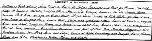
If you had followed the advice on the page Locating Census Addresses on Maps you would have found the census enumerators description is very clear. (If you haven't looked at this before, on Ancestry you can see the enumeration description by selecting the place name from the reference above the image of the actual page, and then selecting the appropriate enumeration district.) The boundary of the Enumeration district is given as:
All that part of Hatfield Civil Parish, Southward and Southwestward commencing at the junction of Marshmoor Bridge Road with the North Road, then along Millwards Park Lane to a point opposite Popes pond holes to the Essenden Boundary.
This is followed by an exceptionally detailed description of the route followed by the enumerator, with many places still identifiable on modern maps.
Using this description you will have, for example, no difficulty in finding Grubbs Lane on any decent online map. If you explore the area round Grubbs Lane on Multimap you will fine Barbers Lodge Farm at the east end of the lane and can get select an aerial photo of the farm. Goole maps does not name the farm but there is a far better satellite picture showing the farm. as it is now:
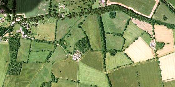
The map shows Barbers Lodge Farm in the middle, with Woodfield Farm to the West and Coldharbour farm to the East. (Click on map for enlargement, centered on the modern farm buildings,)
Barbers Lodge farm house is a grade II listed building, with parts dating from the 16th century (see Images of England web site for details). A William Barber lived there in 1609 (The Place-names of Hertfordshire). It is marked, but not named on Dury and Andrews map of 1766, and named on Bryant's map of 1822 and the first 1 inch Ordnance Survey maps of the same period (obtainable from www.cassinimaps.com). I haven't looked but it should be clearly marked on the 1880s large scale Ordnance Survey maps which are online at old maps. There is not yet an online picture of the farm on Geograph (grid ref TL2605) but thousands of new pictures are being added every day ...